
Author – Cllr Nigel Baker
Only sketchy evidence exists about Kea before recorded history begins. Within Kea parish there are numerous barrows dating from the Bronze Age as well as from the Iron Age. Although some of these are to the west of the A39 the greater number is to the east especially around Baldhu. None of these remains are now extensive but they do show that a scattered population existed in prehistory.
Historical evidence becomes clearer at the time of the making of the Domesday survey in 1086, with small settlements being listed at Landegay (Old Kea) and Goodern. The majority of the land was open downland and used for grazing and fuel gathering. During the medieval period, especially during the 13th and 14th centuries, many new small farmsteads, several of whose names are familiar to us today, begin to be developed together with their associated field systems which were used for both pastoral and arable farming. Extensive remains of medieval field systems survive in areas such as Carrine common. Two manors increasingly dominated Kea, that of Landegay and Goodern, but both manors were owned by large families from outside the parish. Kea stretched over a wide area of some 7000 acres from the Truro and Fal rivers to Kenwyn and Tregavethan.
It was the development of tin and copper mining during the 18th century and into the early decades of the 19th century which probably had the greatest impact in the history of the parish. The Baldhu (the ‘black mine’) area was found to be rich in minerals, this led to the destruction of the old field systems as mines were developed as well as a huge rise in the population of that part of the parish. At the same time the need to smelt tin led to the development of Calenick.
The proximity to Truro, which rapidly grew rich due to trade as well as its role as a stannary town where tin was coined and smelted, also brought increasing wealth to the parish during the 18th and 19th centuries. Several fine houses were built and many farm houses were rebuilt. It was during this period that the population of the parish was probably at its greatest with the Baldhu area being heavily populated. Although the slow decline of mining in the late 19th and early 20th centuries had an adverse impact on Baldhu, where depopulation took place, the proximity to Truro led to the development of Playing Place as a commuter village as well as the building of many detached houses around the parish.
Kea in Myth and Legend
Two stories dominate the early history of Kea, the arrival of St Kea who gave his name to the parish and the story of Tristan and Iseult.
There are many versions of the story of St Kea with some less probable than others. The most fanciful account of St Kea has him floating across the sea from Ireland on a granite millstone. It is more likely that he was a bishop who gave away his wealth, became a hermit and in the late 5th century travelled through Wales, Somerset and Devon and then to Kea, where he founded a small monastery at what is now known as Old Kea – or Landegay (where Ge is Key and Lan means a holy place). Later he went to St Cleder in Brittany where he died.
Kea and the ferry or ford passage across the Truro river at Malpas (‘Le Mal Pas’ – ‘the bad passage’) also features in the famous legend of Tristan and Iseult as told by the 12th century poet Béroul, though inspired by Celtic legend. A Cornish knight Tristan falls in love with an Irish princess Iseult whose husband, King Mark, lives at Blancheland (possibly Goodern) in Kea. This tale predates and most likely influenced the Arthurian tale of Lancelot and Guinevere.
Places of Worship
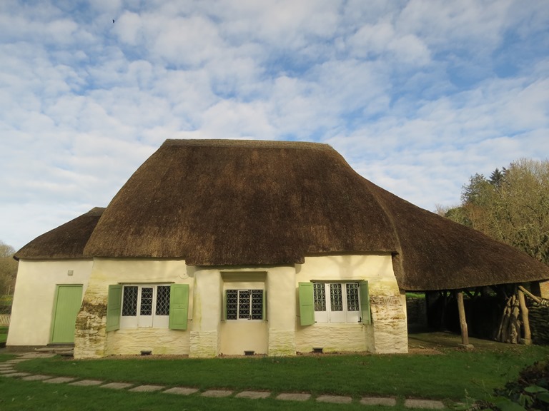
Old Kea Church and Tower is the earliest place of worship and the site of the original small monastery. It is a wonderfully quiet and romantic spot with the ivy clad tower all that remains of the medieval church, together with a very pretty 19th century Mission church.

The medieval church would have been very similar to other creekside churches such as St Clement or St Just-in-Roseland, and also dates from the 13th century. A contemporary painting shows it had two aisles and a large south porch with a sundial. When built it was close to the river and to the major route which linked Truro to the Roseland via the ferries at Malpas and Tolverne, and then to the major south coast pilgrim route which crossed the Fal at King Harry ferry and onto the pilgrims’ destination of St Michael’s Mount. As the population in the rest of the parish grew the location of the church proved inconvenient and as early as 1531 Henry VIII agreed to a petition from the parishioners to demolish it and build another church in a central location. The church was eventually demolished in 1802 when it had become too dangerous to hold services in it. A poor house was built on the site and later in 1853 a mission church was built, and extended in 1862. The Buildings of England: Cornwall describes it as ‘a charming little essay in simple Gothic, incorporating some material from the old building’. Outside the church is an unusual tall stone pillar; it probably dates from the ninth or tenth centuries, it may have been the shaft of a cross, a boundary marker or a standing stone. It is said to have been found in either the foundations of the demolished church or the demolished poor house. Inside the church, under the present font, is a huge granite base which was probably the base of the medieval Kea cross which stood at the forked junction at the top of the hill on the way down to Old Kea. The size of the base suggests the cross was very large, it was marked in Gascoyne’s map of 1699 but by about 1770 it had been taken down as the Coryton Estate map says ‘Here formerly stood the ancient cross called Kea cross’. It was rumoured that the shaft and part of the base was built into a house in Porth Kea, and the remaining half was found lying in a field and taken down to its present position in 1862. Regular services are still held in the church and it is usually open.
All Hallows Church, Higher Kea, was opened in 1802 but its design proved unpopular and soon cracks began to appear and by 1869 it was clear it would have to be rebuilt. After a fund raising campaign, the new church was consecrated in 1894.

It was built of top quality materials and the result was very pleasing. The new edition of the Buildings of England: Cornwall comments ‘One of the most attractive late 19th century churches in Cornwall (though very un-Cornish), beautifully situated in its sylvan setting, the park at Killiow. The interior is especially handsome, of generous and spacious proportions, with a wide nave, narrow north and south aisles with lean-to roofs, and walls of a mellifluous polychromy’. It is strongly influenced by the Arts and Craft movement. The Norman font is from the old church, as is the Poor Box of 1739, and there is much good glass. The choir stalls were given by J C Daubuz of Killiow, and their bench ends are carved with the arms of eight Belgian cities devastated during the First World War. Another feature of the Higher Kea site is Church Cottage, formerly the National Board School, built in 1849-1851 to the designs of William White, one of the pioneers of the Gothic revival in Cornwall, and a celebrated architect who gained national acclaim who also built St Michael’s Baldhu.
During the late 17th and early 18th centuries Non-Conformism was growing in strength and the result in Kea was the building in 1710 by the Society of Friends, the Quakers, of the much admired Meeting House at Come-to-Good.
The Buildings of England: Cornwall says ‘It is beautifully set in its small burial ground and the interior is homely, loveable and almost completely intact…Whatever the derivation of the place name, the building perfectly captures the compelling simplicity and integrity of the Quaker endeavour’. It is likely that the name derives from Cornish words ‘Cwm’ meaning valley and ‘Coed’ meaning wood.
The Church of England grew concerned at the growth of Non-Conformism, especially among the growing industrial working class, and Baldhu had seen a huge growth in population due to increased mining. In an attempt to win back the miners, St Michael’s Church, Baldhu was built in 1847-1848 and paid for by Viscount Falmouth who owned much land and many of the mines in the area.

He also paid for the school adjoining. The church was the first one built by William White who went on to play a leading part in the national revival of Gothic architecture. The church was derelict for many years but in 2009 it was converted into two private houses. The churchyard contains a beautiful well head, also probably by White, as well as an obelisk marking the site of the grave of Billy Bray, who died in 1868 and was one of the most renowned figures in Cornish Methodism (see below).
Non-Conformism continued to thrive and during the 19th century many chapels were built across Kea parish. In 1889 Baldhu Methodist Chapel was built together with an attached schoolroom and is a good example of a Cornish wayside chapel; it is still in use.

Billy Bray (1794-1868) was a miner and drunkard who had a close escape from death with a mining and found religion.

He became a charismatic preacher within the Bible Christian sect of Methodism, did much to help others and raised funds to build three chapels, mainly built with his own hands. Only one of his chapels has survived, the ‘Three Eyes Chapel’ at Kerley Downs built around 1835.

Methodist chapels were also built at Hugus in 1830 and Porth Kea in 1869, they had schoolrooms and a manse at the rear. Both are now private houses. A tiny Bible Christian Chapel was also built at Bethel near Coombe but little is known of it. A large Bible Christian chapel was built at Quenchwell in1906 but closed and after being empty for several years reopened in 2009 as the Cornwall Islamic Community Centre.
Main Settlements
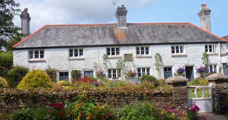
Landegay/Old Kea was listed in the Domesday Book with 9 households comprising 2 villagers, 4 smallholders and 3 slaves as well as 2 cattle, 40 sheep and 15 goats. Much of the eastern part of Kea was part of the manor of Landegay. The manor was owned by the Tregian family of Golden near Grampound but they lost it due to their Catholic faith towards the end of the reign of Elizabeth I. It passed to the Coryton family from Pentillie on the Tamar until they sold it in the 1840s to Lord Falmouth who was already the largest landowner in the parish. The orchards there may have been where Kea plums, a damson famed for its jam making qualities, originated. Coombe is famed in the area as it has hardly changed since the 1930s, and it could only be accessed by boat until a road was built into the village in 1924.

The cottages, most of which were built between 1770 and 1860, are surrounded by orchards where Kea plums dominate. Oyster fishing is still carried on from the village. Cowlands stands at the head of the creek from Coombe.

The attractive mill house, Cowlings Mill, still stands though the mill has long gone. Leases for local farms stipulated that their corn had to be ground there. It was in use during the mid-19th century. The quays were also used for boatbuilding; one quay has public access.
Although the mill in Calenick was mentioned as early as 1300 (first a fulling mill in the wool industry and later a corn mill, and worked as such until 1910) it became important as an industrial centre. Around 1702 a new method of smelting tin had been discovered, the reverbatory furnace, which rather than using expensive charcoal used much cheaper ‘sea coal’ which was imported from Wales. The first furnaces had been built at Newham but moved to Calenick in 1711, probably due to the lack of a good stream at Newham. Tin stamps for crushing tin already existed at Calenick. By the mid-18th century the Calenick works had been added to the business empire of William Lemon (he had built Princes House in Truro in 1739 and in 1748 had bought the Carclew estate, so would have gone through Calenick on his way home each day). Later it was bought by Thomas Daniell, a former clerk to William Lemon (he had built the Mansion House in Truro in 1755) who bought up much of his business enterprises after Lemon’s early death in 1760. The Calenick smelting works became one of the most important in Cornwall and did not close until 1891 when it was owned by the Daubuz family from Killiow. Associated with the tin smelter is one of the finest houses in Kea, Calenick House, which dates from 1702, is in Queen Anne style and is a smaller version of Trereife near Penzance.

It was used for much of its life as an account house for the smelting works. The clock tower was built in 1752, it contains the original clock and a bell inscribed ‘William Lemon’. Ropewalk Row, from the 1760s, is a good example of early industrial housing being built for the senior workers at the smelting works. As well as smelting, Calenick also manufactured crucibles which were used in assessing the purity of tin, and exported to the developing tin industry in Australia. The quays, vital for the import of Welsh coal, have largely disappeared as has the extensive rope walk. Boat building also took place on the quays. A toll house still exists near the bridge which was on the then main Truro-Falmouth road. The creek has silted up due to the huge amount of waste washed down from the tin mines; in 1877 alone it was estimated that 10,000 tons of silt were deposited in the creek. Calenick was also the birthplace in 1807 of the popular Victorian poet Nicholas Michell whose father John managed the Calenick smelting works and discovered the mineral ‘tantalite’; Nicholas died in 1880 and is buried in Higher Kea churchyard.
Porth Kea lies on a narrow ridge which links the manor of Landegay with the rest of the parish. At the end of the 18th century it was a small community with a smithy, an inn, as well as several cottages. Many of these have disappeared but a chapel (see above) was built in 1869 and many bungalows have been built in recent times.
Playing Place gets its name from the medieval round or Plain an Gwarry in which plays would have been performed during the medieval period, including ones celebrating the life of St Kea.
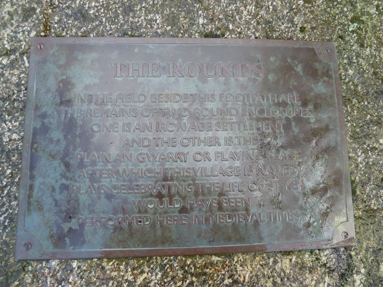
In 2000 a Cornish language play, Beunans Ke, was rediscovered in which St Kea was harassed by a Cornish king, Teudar, when he sheltered a deer that Teudar was hunting. St Kea’s dealings with King Arthur are also described. In 1726 a group of almshouses were provided for in the will of Mr John Lanyon for eight poor people and endowed with an estate in Gwennap.
Originally the men lived on the ground floor and the women on the first floor, but now it provides four houses. Playing Place is by far the largest village in the parish but, except for the Lanyon Alms houses and two farms, the rest of the settlement dates from a great surge in building which began in the 1920s.
The small hamlet of Bissoe is surrounded by spoil heaps and was once an important industrial complex. Remains of tin streaming date from the medieval period but from the 18th and 19th centuries there are the ruins of ochre pits, copper works, an iron foundry, tin smelting and an arsenic works.

It also contains the mouth of the County Adit, a system of drainage tunnels built in the 18th century to drain the Gwennap mines. Bissoe was also an important point on the Redruth-Chasewater railway which linked the mines around Gwennap to the port of Devoran. It was completed in 1825 as a horse drawn tramroad, converted to locomotives in 1854 and closed in 1915.
Important Houses
The largest house In Kea is Killiow, which can be seen from the A39 at Playing Place. The present Classical front dates from about 1850 but the house itself is far older. The families who have owned it – Haweis, Gwatkin and Daubuz – have all been significant landowners in the parish and benefactors to both Old Kea church and All Hallows.
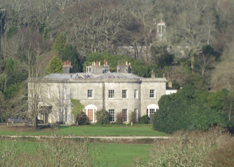
The last Daubuz to live at Killiow, J C Daubuz, did much to encourage the fruit industry in the parish. On his death Killiow passed to a distant relative, Miss Coode, and the Coodes lived there until it was bought by the Penrose family in 1948, who sold it in the 1990s. Annie Penrose, who died in 2011, gave her childhood nickname “Little Spitfire” to the famous aircraft. Her father, Sir Robert McLean, played a crucial role in the development of the plane as chairman of Vickers Aviation working closely with the designer RJ Mitchell. When it came to giving the new fighter a name, he suggested the affectionate term he used for his spirited elder daughter.
Penelewey is a very fine example of a house which was remodelled in 1710 and, unusually for this area, was given a brick front (as has the nearby farmhouse of Treloggas).
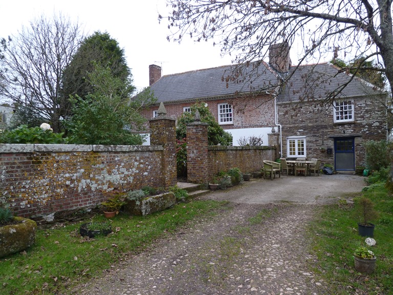
It retains many fine features, notably the windows with crown glass, and the interior has survived virtually intact. The gate piers and garden wall also date from 1710. There is probably some connection between the remodelling of Penelewey and the building of the Friends’ Meeting House at Come-to-Good. Both date from 1710, Penelewey and the land on which the Meeting House was built, were owned by James Mayo, a Quaker. It is possible that some of the lintels and windows in the Meeting House were taken from Penelewey when it was being remodelled. A very intact mid-19th century planned group of farm buildings lies close to the house.
Calenick House, see section on Calenick.
Woodbury lies just below Malpas on the Truro river. The present house dates from the 1790s and was a gentleman’s residence conveniently situated close to Truro.

It once had a formal garden with terraces, known as The Walks but long since overgrown. Another such residence lies on Lambe Creek opposite Malpas, once known as Sunset it has more recently been called Lambe Creek House.

It was remodelled in the early 19th century and was lived in by an Admiral Temple. In the 1930s and 1940s it was owned by the Penrose family (who later bought Killiow). During this time it attracted many celebrities as its owner, Beakus Penrose, was then married to the sister of the actor Robert Newton and he and other film stars were often seen in the area. Beakus Penrose’s brother was Roland Penrose, a famous art collector who introduced Surrealism to this country. In the summer of 1937 a famous party took place at Lambe, it was described as ‘a heady mixture of free love and artistic intercourse’ and included celebrities such as the artist Max Ernst, the model and photographer Lee Miller. Henry Moore was another frequent guest.
Schools
The National School buildings at Baldhu, opposite St Michael’s church, and at Higher Kea were both built around 1849. A Board school in a more central location was opened in 1879 and now fills the role of the area primary school.

Population and Occupations
The present population of Kea, about 1500 adults, is largely made up of the retired, of those who work in Truro and those who still work in agriculture. In 1801 the population was 2440 but by 1841 this had soared to 4313 and remained close to this figure throughout the 1840s, 1850s and into the 1860s. This was as a result of the growth of mining in the Baldhu area, but during the 1870s and 1880s the mining industry went into sharp decline due to the expansion of mining overseas. As a result many Cornish people emigrated, particularly to Australia, and through the 1880s and 1890s the parish population was around 2000. Its lowest point came in 1951 when only 1349 adults were recorded as living in the parish.
Mining and smelting (see sections on Calenick and Bissoe) were the largest occupations and in the 18th and 19th centuries dominated the parish. A large number always worked in farming. Farms were very much smaller, they were not mechanised and employed many labourers as well as domestic servants. The Fal and Truro rivers provided a great deal of employment. Large ships, originally sailing and later steam, could not reach Truro so they tended to moor lower down the river where their cargoes would have been transhipped into sailing barges to be taken up river. The empty ships needed ballast for their return trip so many riverside quarries provided the ballast which was taken out in barges. In the days before good road transport the river was the main highway and every riverside hamlet and farm would have had its quay where lime, coal, sand for the fields and much else was brought in. Coombe, Cowlands, Old Kea and Woodbury provided bargemen and pilots for these ships and barges. Much timber was brought in for the mines and all this was rafted up to Truro. Oyster dredging and fishing were major seasonal occupations.

The oak woods of the river valleys were cut down every thirty or forty years, it was known as ‘rinding’, to provide the oak bark for local tanyards and coppice oak for domestic fuel.

Coombe, Cowlands, Old Kea and other areas had extensive orchards both for their famous Kea plums, which made superb jam, as well as for apples. The orchards at Woodbury, Trevaster and Trethowell were famed for their cider.
